 Google maps recently had added Google Earth Ocean showcase, and continues map innovations by hitting Lab Experiments to Maps.
After hitting almost every service, Google is here to test out new features in Maps. These new lab experiments brings alot of desired features, which were earlier limited to Desktop client, Google Earth. Click the green flask at the top of Google Maps and you get a chance to enable features Listed below:
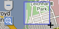
- Drag ’n’ Zoom: Click the Drag-and-Zoom button, then draw a region on the map to zoom into.
- Aerial Imagery: (available in select regions) Aerial imagery gives you rotatable, high-resolution overhead imagery presented in a new perspective. This is helpful, sometimes.
- Back to Beta: This does nothing much, just add a “Beta” icon to the Maps logo.
- Where in the World Game: This is a game for Geography lovers, guess the name of the country from the image.
- Rotatable Maps: This puts north facing downwards, for instance.
- What’s Around Here?: This will trigger a search for anything (“*”), showing the top places for a given location. Pretty helpful finding all known places around the region of interest.
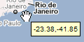
- LatLng Tooltip: Shows the latitude/ longitude of where your cursor is positioned. A brilliant thing to pinpoint a location.
- LatLng Marker: Adds an option to the context menu that lets you drop a mini marker showing the latlng of the position that the cursor was pointing at when the context menu was evoked
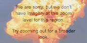
- SmartZoom: Zoom just right. Ever saw the message “We don’t have imagery at this zoom level”? Ensure you don’t see it again, with Smart Zoom, which will check in advance what imagery exists, and ensure you can’t zoom in beyond it.
More labs to come, stay tuned.
We write about Google, Open Source, Programming, Web, Apple, iPhone, Android and latest in Tech @taranfx on Twitter or by subscribing below:
GD Star Rating
loading...
loading...
GD Star Rating
loading...
loading...